
X-Plane – My New Playground
ortho4xp
This uses digital elevation models and satellite imagery to rebuild the underlying base of the flight simulator world. I used the data from the SRTM 3 arc second data set downloaded from http://viewfinderpanoramas.org/dem3.html.
For satellite imagery, ortho4xp has a downloader that extracts images from cough*cough a major web map provider. Unfortunately the data around Malaysia is not very consistent, as they were composited from different satellite passes. So some parts of the images are a different tone from the other.
world2xplane
This grabs data from OpenStreetMaps and places 3D objects and roads where they should be. While OSM Coverage of road details are only so-so, the building data (especially building height) is even worse. So there aren’t that many buildings as there should be (I spent the week before updating all the buildings in Damansara Damai). Looks like I should spend my free time adding more buildings to OpenStreetMaps.
X-Plane Gateway Scenery
On top of this goes the stock X-Plane airport scenery, which are mostly user-contributed (Subang Airport and KLIA pictured below were done by me).
And here are the results …
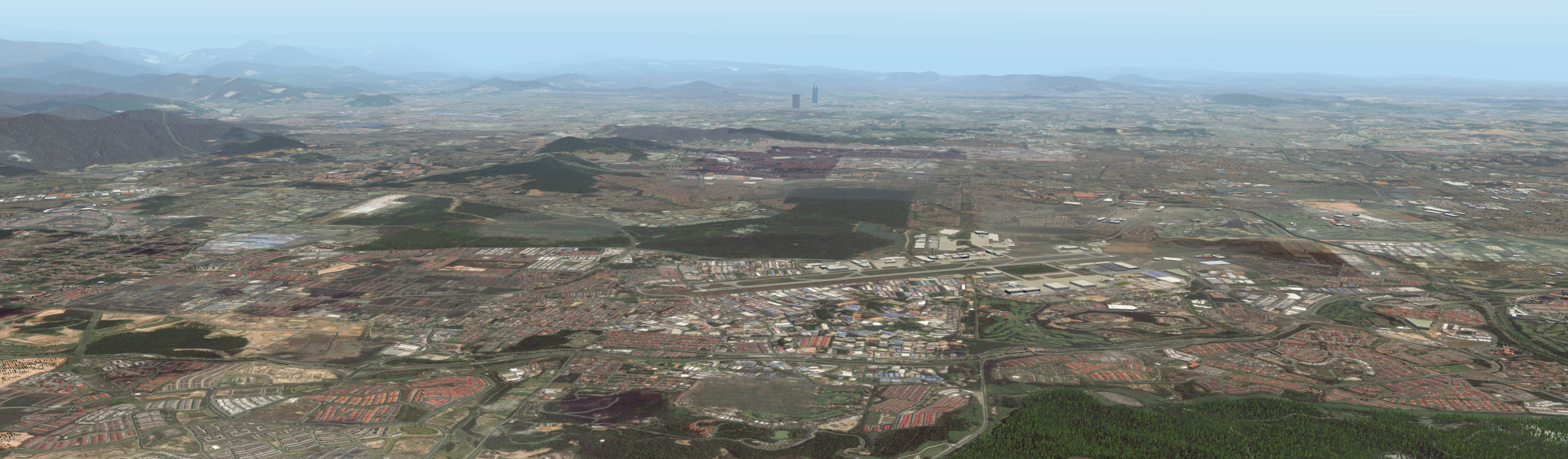
Subang Airport (WMSA). If you know your geography you can make out the 3D buldings in Damansara Damai and also some factories in Sungai Buloh.
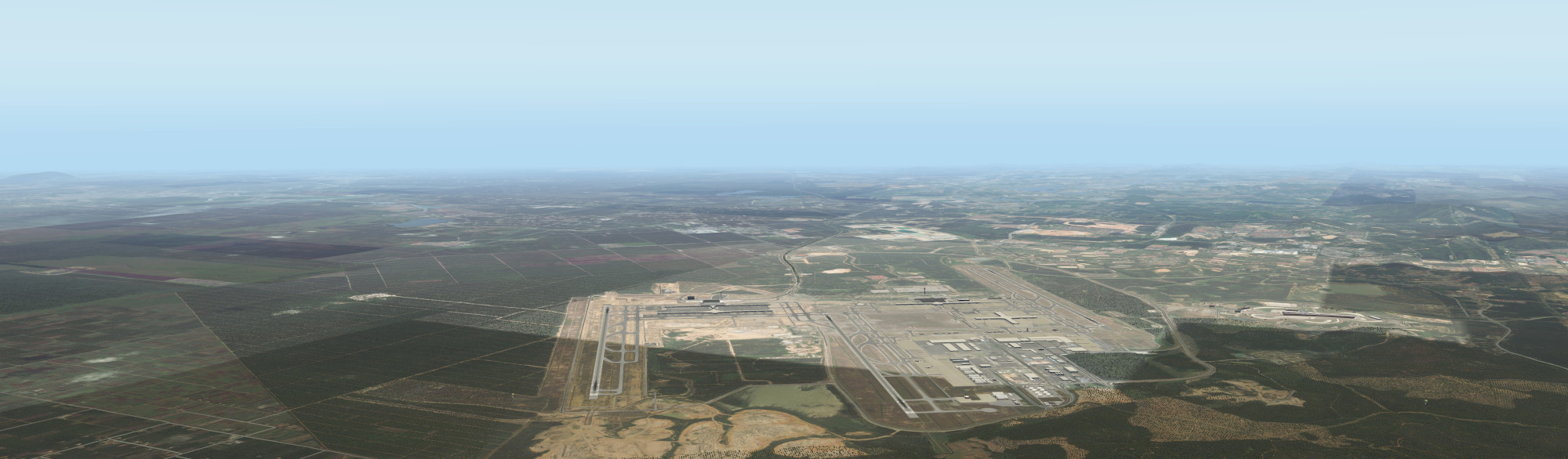
Kuala Lumpur International Airport, KLIA (WMKK). The images are made from a patchwork of sources so you can see they aren’t a consistent tone here.
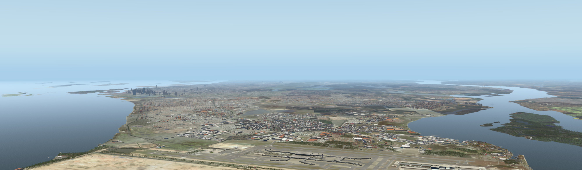
Singapore Changi (WSSS). There is much better OSM data here so you can see a lot of 3D buildings.
Comments (6):
- 2016-07-22 18:53:51+0800 Rashdin Zahari Can you make the WMSA scenery for FSX please. I really love it +shahada abubakarGreetings
Rashdin - 2016-07-23 00:40:50+0800 shahada abubakar Sorry, I don’t have FSX so I’ve no idea how to go about it. Hehe most of the time people are trying to convert FSX scenery to X-Plane. 😎
- 2016-07-23 00:57:38+0800 Rashdin Zahari +shahada abubakar then it is ok to do other way around hehe. anyway, can you send the WMSA scenery file to my email please. I really appreciate if you can send it to me. Thank youthis is my emailrashdin86@gmail.com
Rashdin
- 2016-07-23 02:20:21+0800 shahada abubakar For the WMSA airport itself, mine is distributed standard with X-Plane now (but you can also download it individually from https://gateway.x-plane.com/scenery/page/WMSA).For the surrounding tile overlay with satellite imagery and openstreetmap objects, you’ll need to run ortho4xp (http://forums.x-plane.org/index.php?/files/file/29120-ortho4xp/) and world2xplane (http://forums.x-plane.org/index.php?/files/file/33450-world2xplane-application/). This will download and generate the surrounding scenery. At zoom level 17 just the 3N103E tile is about 7.5GB.
- 2016-07-23 06:45:13+0800 Rashdin Zahari i just dowloaded the WNSA file from the website and there is one folder(COPYING) cannot be opened. I am not sure what format of this file. can you tell me what is the format of this particular file(COPYING) +shahada abubakar
- 2016-07-23 07:46:48+0800 shahada abubakar COPYING is not a folder, it’s a file. It’s actually a text file containing the license terms and conditions for using the scenery, in this case the GPL.If you’re using X-Plane you just unzip the whole thing into your Custom Sceneries folder. If you’re not using X-Plane … then i don’t think there’s much use for the scenery. 😎
This post was originally published publicly on Google+ at 2016-07-17 23:41:15+0800

